The "region" I am describing is as followed and covers the likely areas where problems and issues may arise:
- North border: Sloat Blvd.
- South border: John Muir Drive (southern rim of Lake Merced and straddles between SF and DC border).
- East border: 19th Avenue
- West border: Great Highway and Skyline Blvd.
**MAJOR PROBLEMS: MUNI RE-ROUTES AND SKIPPED STOPS FOR THE 18-46TH AVENUE AND 88-BART SHUTTLE**
I called 311 to find out about the re-routes for the 18-46th Avenue and BART shuttle, and the news is not very good.
MUNI RE-ROUTES/CHANGES EFFECTIVE: MONDAY, OCTOBER 5TH to SUNDAY, OCTOBER 11TH
The 18-46th Avenue bus line is going to hell:
- Going towards Stonestown (SF State area): At 47th and Sloat, re-route turns right on Sloat, left on Great Highway, right on Skyline, and continues normal route. Route will skip: SF Zoo, Skyline & Sloat, Herbst road (Disabled center, SF Zoo staff entrance), Harding park entrance/sewage plant entrance.
- It's "normal" route (map points "A" to "B") would turn left on Sloat, right on Skyline blvd., and turn into Herbst Road before continuing on Skyline.
- Going towards Legion of Honor: At Winston & Lake Merced, re-route turns right onto Lake Merced (northbound), left before road changes to Sunset Blvd., continues down Lake Merced Blvd, turns right onto Skyline, and bus continues normal route.
- It's "normal" route between map points "A" and "B" would turn left at Lake Merced/Winston, go southbound on Lake Merced, turn right on John Muir Drive, turn right on Skyline, and continue on it's route to map point "C" and turn right on 46th Avenue.
When you take a look at the maps, it shows a poor planning from the SFMTA/Muni. Look at the huge gap of service on the lower map, it literally removes all stops from Lake Merced/Winston, John Muir Drive, and Skyline (including the Center for the Disabled on Herbst).

I have officially lodged a complaint via 311's phone line about the 18's route changes:
- You cannot disenfranchise service to these remote areas on the southern rim of Lake Merced (not boulevard, it's the lake) by not having the re-routes try its best to cover the areas where the roads are closed.
- The re-route removes all bus service to the Center for the Disabled; who will supplement service for this problem?
- The route going towards the Legion of Honor is the worst because it skips all the stops on Lake Merced Blvd. south of Winston, and the homes on John Muir drive near Skyline. Every time I ride the 18, I see SFSU students who live on John Muir hop on the bus and pay the $2 fare for a short 5 minute ride, versus walking 30 minutes on the very long walk to/from campus.
- How about the old and disabled people who depend on that bus line to these far away regions? Do you know how far you have to walk?
- Why is there NO INFORMATION ON THE SFMTA WEBSITE?
- DID YOU TAKE AN OPPORTUNITY TO SEND NOTICES TO AFFECTED RESIDENTS AND THE SF STATE UNIVERSITY COMMUNITY?
- HOW CAN MUNI DO THIS TO THE PUBLIC??????
For the 88-BART shuttle:
- Inbound towards Balboa Park Station will operate normally.
- Outbound will be re-routed due to closure of westbound John Muir Drive. At southbound Lake Merced Blvd. and Font (corrected), bus will continue on Lake Merced, cross the Daly City border, turn right on John Daly Blvd., turn right on Skyline Blvd., cross San Francisco border, and turn right onto John Muir Drive eastbound.
--------------------
In this situation, there will be road closures around the golf course. This information is posted on the SFMTA's website, under the ISCOTT minutes (see here), be aware that this information is NOT yet posted on the "alerts" page of both SFMTA and 511.
Here's the road closures:
- John Muir Drive between Lake Merced blvd. and Skyline (westbound only).
- Herbst street (home to the Center for the Handicapped, SF Zoo staff entrance, and the National Guard).
- Skyline between Lake Merced Blvd. (the road that goes around the north west portion of the lake) and Great Highway.
- Lake Merced blvd. between Sloat and Brotherhood will be bad, especially with the extra spectator entrance they've installed near Font.
- You can still take Skyline, but you are forced to use Great Highway to go around the closure between Great Highway and Lake Merced.
- I won't bet on this, but Sunset Blvd. may become a nightmare going Southbound.
SF State University students, staff, and faculty... what should you do?
- If you are going to park in the garage, bring your campus ID. Campus cops will kick-out any golf spectator who uses the garage that is exclusively for university affiliates.
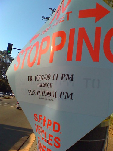
- PARKING IS BANNED (see photo below) on Lake Merced Blvd. between Winston and Font. This will be a heavy impact on the campus garage due to the large amount of street parking in that area.
- If you are taking public transit, expect delays on the 29-Sunset and 18-46th Avenue.
- Arrive to campus EARLY. Get yourself a nice breakfast on-campus.
- If you live on John Muir drive and take the bus the campus, you may want to consider carpooling with a neighbor. Muni coverage will suck. I suggest complaining to your city supervisor and Muni officials NOW.