"Akit is the man. He knows Clipper." (spenta)
"It’s a fantastic blog for any San Franciscan."
(Kevin)
"Your blog is always on point, and well researched!" (Nina Decker)
"Everyone's favorite volunteer public policy consultant..." (Eve Batey, SF Appeal)
"You are doing a great job keeping on top of Translink stuff. Keep up the good work!"
(Greg Dewar, N Judah Chronicles)
"...I don't even bother subscribing anywhere else for my local public transportation info. You have it all..."
(Empowered Follower)
"If anyone at City Hall wants to make public transit better for all San Franciscans, it would be wise to follow Akit religiously...
or, better yet, give him a job."
(Brock Keeling, SFist)
Showing posts with label Lake Merced Boulevard. Show all posts

Sunday, June 10, 2012

Your Survival Guide to the USGA's 2012 U.S. Open at SF's Olympic Club

NOTICE: Taking BART to the U.S. Open on Thursday?  READ THIS.

Another big golf event means raking in the tax dollars for the city, but also means headaches for us locals just trying to go on our merry way.

So here's my survival guide to you, the average citizen who doesn't care about golf.

The USGA's 2012 U.S. Open will be held at the Olympic Club, located in the very deep southwest corner of San Francisco and straddles between the borders of San Francisco and Daly City.

The location of the course is surrounded by four major streets/roads: John Muir Drive (North), John Daly Boulevard (South), Lake Merced Boulevard (East), and Skyline Boulevard/Highway 35 (West).  While the Olympic Club is closed to the public as it is a private club for the wealthy, the U.S. Open will make it open to the public with the purchase of a ticket.

The tournament is scheduled to go from Monday, June 11th to Sunday, June 17th with practice rounds on the first few days, and the rest as the tournament.  Crowds and major media attention is likely going to peak during the last final days, especially during the weekend.

Traffic Problems
From what is currently known from the U.S. Open, an article from SFGate, and SFMTA/Muni's websites, there are some key road closures that will definitely put a dent in your commute.

Skyline Boulevard (Highway 35) in the northbound direction will be closed from John Daly Boulevard to John Muir Drive from approximately 5AM to 10PM during every operating day of the U.S. Open.  The southbound direction will have one lane closed between the two streets, but the other lane will remain open.

John Muir Drive, which borders the northern end of the golf course, is closed to traffic.  It is scheduled to close starting at 6AM on Sunday, June 10th and will remain closed until 6AM on June 18th (as per SFgate).  However, contradictory to what the Chronicle is saying, the 18-46th Avenue bus line will still be able to go eastbound on John Muir (as per SFMTA), but is unable to go westbound.

There is also the likely possibility of a traffic jam on the east side of the golf course along Lake Merced Boulevard.  Between John Muir Drive and John Daly Boulevard is the community park and will be the staging area for all taxis and limos as drop-off and pick-up points.

Better alternate routes:

Take 280 and 19th Avenue:

Take Sunset Boulevard which changes to Lake Merced Boulevard, Brotherhood Way, and 280.  UPDATE: This is not a great route, southbound Lake Merced Boulevard can get jammed by heavy traffic all the way from Font, but once you make the turn to Brotherhood, traffic flows fast.  An alternative is to make a left turn onto Winston towards Stonestown and turn right onto 19th Avenue.


Parking Problems
As there will be incompetent people on the road looking for a sweet parking space to go watch golfers stroke their [three] wood and wash their [golf] balls, expect major parking problems in the surrounding areas.

As always, there will be those golf spectator idiots who thinks parking in a private parking lot such as Burger King's or the Westlake Shopping Center is a great idea.  I'll tell you, it's not, and expect a nice tow truck to haul the car away.  They probably have extra security watching over the lots.

Here's a list of areas where parking might get hard, and these are areas where it's "close" to the entrance on John Muir Drive.  BUT in reality, parking in one of these areas means one hell of a long walk.
  • South end of the golf course, such as near Joe's of Westlake (they do make a great Steak a la Bruno).
  • Lake Merced from Winston to Font.
  • SF State and Parkmerced area (most parking is limited to one hour).
  • Merrie Way (Janet Pomoroy Center).

One way to definitely piss-off a lot of people is to park in the SF State garage.  If you have no university related business, stay the hell out.  You seriously don't want to mess with students, faculty, and staff; the lot is for them so they can go to or teach class, or do their jobs as university officials.

UPDATE: Golf spectators with a special permit to park in the SF State garage is permitted to do so.  If you don't have one of those permits, you'll be turned away.  SF State students, staff, and faculty should be prepared to show their campus ID, employee parking permit, or have a legitimate reason to park on-campus.

Public Transit Problems:
There's only two bus lines that runs close to the action: Muni's 18-46th Avenue and Samtrans 122.

Samtrans may encounter traffic, but Muni will feel the pain.  All 18 line service going from Legion of Honor to Stonestown will operate normally.  All 18 line service going from Stonestown to Legion of Honor will have to be re-routed.  See maps below.

This is the normal route the 18-46th Avenue line takes to go from Stonestown to Legion of Honor (via westbound John Muir):

This is the detour the bus must take due to the westbound John Muir closure:

If you are trying to get to the event...
The parking lot is at Candlestick Park.  You think I'm kidding?  No.  There will be luxury shuttle buses transporting people to and from the stadium's lot to the golf course.

For those of you riding BART, take the train to Colma station (NOT DALY CITY) and board a shuttle to the golf course.  Please remember, parking in Colma station to ride the shuttle is a violation of BART parking policy and will be cited and/or towed; it is only for BART passengers.  Park at a different BART station, pay the parking fee (if applicable), and take the train to Colma.  Go to BART's website and get information about parking and how to get a reserved parking space permit.

For more information, please visit:
USGA Spectator Guide (Transportation Info)
SFMTA/Muni 18-46th Avenue affected routes
SFgate article on U.S. Open

Sunday, October 31, 2010

A Local's Survival Guide to PGA Charles Schwab Golf Tournament at SF's Harding Park

The PGA Champions Tour is returning to San Francisco at Lake Merced's Harding Park golf course. I've read over the material and found out this event won't be as bad as other times where streets have been closed-off, certain areas turned into defacto parking lots for the rich and wealthy, and Muni lines were seriously re-routed. With much less traffic and transit restrictions, it looks like this might be a much lower profile event than the other two that snarled the area and made a lot of SF State students, faculty, and staff upset; one huge reason, a one day ticket is only $25, while the last two events charged at least double or triple.

Here's an easy guide to a smooth experience during this golf tourney (whether you are a local trying to get around or just wanting to see golfers wash their balls):

Event dates:
  • Held from Monday, November 1st, to Sunday, November 7th.
  • Monday and Tuesday is not for the general public.
  • Wednesday through Sunday is for the general public to access. Practice round is Wednesday, and tournament play is the remaining days.
Traffic Closures:
  • The SFMTA's ISCOTT meeting agenda states in item "R," Herbst road that services the Janet Pomeroy center, National Guard, and the delivery entrance for the SF Zoo will be closed from 6:30AM to 5:30PM each day.
  • This is the only noted road closure from the ISCOTT notes, thereby any other closures could be deemed illegal because only ISCOTT can approve city road closures (that is, unless there's an emergency).
Transit Changes:
Parking:
  • Sanctioned parking lots are located at the Stonestown Mall from Wednesday to Sunday, and SF State from Saturday to Sunday (see map).
  • Parking in the street might get tricky, especially with the heavy restrictions and time limits in the SF State area.
  • Don't park in the SF State garage until the weekend. Campus cops are watching, and you don't want to mess with thousands of students, staff, and faculty who uses the lot on a daily basis.
  • Do not park in Daly City BART to take advantage of the free shuttle. The BART lot is for passengers only and registering the car in the paid area of the station is REQUIRED. Abusing the system will result in a large fine and/or towing.
Transit options to event:
  • BART: Daly City station will have shuttles.
  • Muni: 29 Sunset provides service to the main gates near "Sunset Circle" (a.k.a. where Lake Merced Blvd. and Sunset Blvd. meets). L-Taraval is a walk to the main gates from the terminus stop at the Zoo. 18-46th Avenue passengers should exit at Sloat and Skyline and walk to main gates. 23-Monterey passengers should exit at Sunset Blvd and walk.
  • Bike: Free bike racks at "Sunset Circle" main gates.
  • Taxi: Drop-off on Lake Merced between Sunset and Skyline.
  • See complete map.

Here's some local resident tips if you are just trying to avoid this train wreck:
  • Great Highway between Sloat and Skyline is now fully opened in both directions. This will ease the traffic that will happen due to the golf tourney along Skyline.
  • If you are commuting along the 18-46th Avenue and 29-Sunset, expect some delays due to traffic.
  • If you work for the SF Zoo or need access to the Janet Pomeroy center, hopefully they informed you about the road closure.
  • You might want to avoid the Sunset Circle area and the adjacent roads.
  • If you work or go to SF State, arrive a little earlier. If you depend on street parking, you should definitely get to campus much earlier if those golf spectator cheapskates steal all the parking.
Let's hope for a smooth golf tournament and minimal road or transit hassles.

Tuesday, September 9, 2008

Transit Effectiveness Project (TEP): SF Muni's Bad Ideas for 38 and 18 Lines

Many people may or may not know that I live in the Outer Richmond District. I noticed a little while back that San Francisco Muni had released these new proposals to modify many of the transit lines that we are so used to. But two of my local lines really started to hurt.

Since I cannot go to the hearing on Tuesday the 16th because I'm stuck at work, I e-mailed the SFMTA Board of Directors as requested by the TEP representatives, but I don't even know if they will even read my lengthy comments. So I'm going to post my ideas here:

For the 38-Geary line, the proposal by Muni will eliminate the Ocean Beach branch of the line. Currently the three major branches is: Ft. Miley (38 regular), Ocean Beach (38 regular), and 48th Avenue and Pt. Lobos (38 limited). I really think they are going in the wrong direction with this and should plan to restore service to the Ocean Beach terminal. I can understand that having huge articulated vehicles running on Balboa Street is not the best idea due to bus noise and the narrow lanes in certain sections, so it might work best if the line runs the 38-Limited route, but goes down Pt. Lobos past the Cliff House to the Great Highway and turns at Fulton to the Ocean Beach terminal. The inbound route will follow the opposite direction, but stop at the 38-Limited terminal for an easy transfer to the limited line.

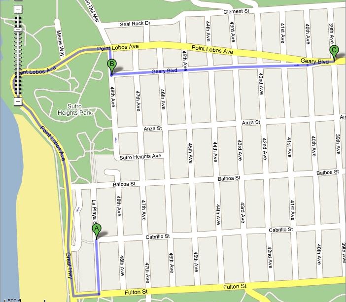
(Inbound daytime service starting from Ocean Beach Terminal)

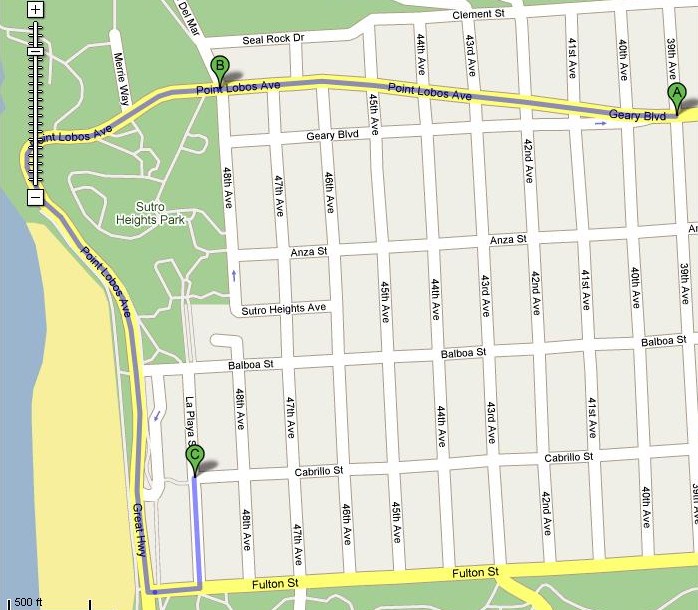
(Outbound daytime service to Ocean Beach terminal)

Muni's TEP people also proposed changing the 38-Geary Owl service to not terminate at the Ocean Beach terminal, but to stop at the Fort Miley terminal. I think Muni should take an opportunity to increase their coverage on the owl service line by serving all three terminals. People are used to taking the 38 Owl to Ocean Beach, so why not restore it and also serve the neglected areas like 48th & Point Lobos, and Fort Miley hospital? The area around here is very hilly, and for people who live north of the Ocean Beach terminal live on an extremely steep hill. Still, it follows my proposed route modifications, but will eliminate the loud noise on Balboa street since that line runs 24-hours a day in a neighborhood. Passengers who live on Balboa can easily take the 5-Fulton owl service and walk two blocks on a usually flat or slightly pitched sidewalk.

(CORRECTION: The 38-Owl service is proposed to terminate at 48th Avenue and Pt. Lobos, however this error still does not change my argument to serve all three terminals)


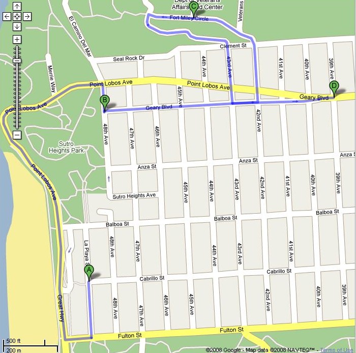
(Inbound 38-Geary Owl service route serving all three terminals)

(Outbound 38-Geary Owl Service route serving all three terminals)

Lastly, the 18-46th Avenue line's modifications are not really acceptable. While I did not make any maps, I'll point out the changes that might take place. To give some background on the 18-line, the bus line is one of the best lines in the entire city, easily accessible route to SFSU, and only the most senior operators with the best reputations get to drive this line (because everyone wants to drive it).
  1. In the northern section (above Golden Gate Park) of the route, it is proposed to remove the route going around the Cliff House by having the line actually drive through Balboa and turn North to serve 33rd Avenue and Geary. This route will slow down the line's current efficient route because Balboa is a "stop and go" type of road, and I think in the best interest of the neighborhood, eliminating the noisy gas powered buses will be a real help. And the people at Balboa can ride on the quiet 31-Balboa line to the Ocean Beach terminal to ride my proposed modified 38-Geary Ocean Beach branch line or the 18, or can even walk two block to ride the new proposed 5L-Fulton Limited line.
  2. In the area around Lake Merced, the TEP proposal will not go around John Muir Drive (the southern edge road of Lake Merced) and will run on the northern end of Lake Merced. It is true that it will make the ride faster, but it has a major disadvantage. If you have ever driven the south edge of Lake Merced, John Muir drive has this big apartment complex, and when I ride this bus, a lot of SFSU students, staff, and faculty board the bus for a direct ride to SFSU. The TEP proposal eliminates this and moves the 17-Parkmerced line to serve this area. However, this change will nearly triple the time it takes to get to SFSU because the eastbound bus will go into Daly City to pick-up Daly City BART passengers, and wind through the road maze known as Parkmerced. If the 18-line stays the way it is, it is only adding a five minutes to the route, and just that few minutes can bring in extra money to Muni since SFSU folks at John Muir drive depends on this route for direct service to campus.
  3. Also noted about the route change on Lake Merced, there is no easy to access bus stop for SFSU students at all. All SFSU affiliates get-off on the current route at Lake Merced and Font Blvd. (the dorms) and take a short walk to their classrooms. The new route will make people walk a longer route to make it to campus since it does not make a direct stop at campus, thereby may not make the line suitible for SFSU affiliates. This is especially discouraging for SFSU people who attend or work on the west end (lower end) of campus versus the east end ("up-campus") of campus. I use the 18 for a direct ride to SFSU, and if this route goes into effect, I might just drive to campus.
Thanks for reading. Below is the original letter I sent to the SFMTA Board of Directors:
--------------------------------------------------
Dear SFMTA Board of Directors,

I am e-mailing the SFMTA Board of Directors today to post my comments on some of the proposed changes to the lines serving the Outer Richmond district.

In regards to the proposed removal of the 38-Geary Ocean Beach branch line, I believe that this line is still very useful during its daytime operations as it also is part of the late night owl service used in today's Muni service.

--First of all, I believe the daytime route should be modified outbound to go straight down Geary and down Pt. Lobos on the road towards the Great Highway (passing the Cliff House) and going directly to the bus terminal. For the downtown trip, it would start at the Ocean Beach terminal, go up Pt. Lobos past the Cliff House, right turn at 48th Avenue to drop-off/transfer passengers for the 38-Limited for a faster ride (this will be a popular option for passengers!), and continue on Geary on the normal route. This alternate route is faster, gives easy access for tourists to visit the Cliff House, eliminates the "stop and go" driving on Balboa, use of noisy motorized buses on Balboa, and 38-Ocean Beach branch line passengers can still get to their destination on Balboa by simply transferring to the 31-Balboa line.

--The Owl line route should also help out more residents of the Outer Richmond too. Currently, the only 38-Geary route Owl service is the Ocean Beach branch. However the proposed modification would remove the route and terminate at the Ft. Miley hospital for owl service. Since the 38 line is one of the main lifelines of this city, I feel it best if the line should serve all three major terminals in one route so that it can accomodate everyone, espeically the very hilly parts of the Outer Richmond that makes it a challenge for older passengers (this is especially true in the 40th-48th avenues where the hills are steep between Cabrillo and Geary). My suggestion is to have the outbound owl buses serve in this order: Ft. Miley (by request), the bus stop at 48th Avenue and Pt. Lobos (northwest corner stop, diagonally opposite of the Seal Rock Inn), and terminate at Ocean Beach terminal (by driving on Pt. Lobos (going past the Cliff House). For the downtown route: Ocean Beach Terminal, 48th Ave. and Pt. Lobos terminal, and Ft. Miley by request of activation of the signal at Ft. Miley. If there is a concern about regular Owl passengers losing their service on Balboa, it should be noted that the 5-Fulton is an owl service line and Balboa is only two blocks away with little or no hills to climb and could calm the motorized bus noise problem dramatically.

I also disagree with the proposed changes to the 18-46th Avenue line. The current route of the line is very efficient, fast, and is considered one of the best bus lines in the entire city; even to the point where Muni operators highly desire to drive on this route.

--The modified route on the northern sector of the city will cause much longer driving times and does not serve any real convienence. Balboa is a very "stop and go" street and I believe that not using Balboa for this modified route will reduce the vehicle noise and help out the neighborhood at large since the 31-Balboa is a trolley bus line. If you are wondering if this will cause any problems for Balboa St. passengers, they can easily ride the 31 to the Ocean Beach terminal for the 18 or ride my proposed modified 38 Ocean Beach branch. Also, removing the 18-46th Avenue's service area covering the Cliff House and 48th Avenue/Geary to 33rd Avenue/Geary will hurt tourism for the Cliff House and the many residents who rely on an easy and direct route for many services (SFSU, SF Zoo, Stonestown, etc.) and connections to other major Muni lines.

--I am also aware of the removal of 18 service on the south end of Lake Merced (John Muir Drive), where it is proposed to be more efficient to run on the nothern rim of Lake Merced. I do agree that this route modification will improve service, however this does cause problems for students and employees of SFSU. The new proposed change will make it much harder to access SFSU as there is much more walking involved. Many SFSU students and staff exit on the current route at Lake Merced and Font, next door to the residence halls (dormitories) and most SFSU students to not exit at the end of the line (Stonestown) to walk half a mile to campus. There are also many SFSU students and employees who live at the apartments on John Muir Drive, and if the proposal goes through and the 17 line serves this route, there will be no fast direct access to SFSU for these people. The 17's modified route serving the John Muir Drive apartments would have to go through a dizzy maze serving other parts of Park Merced and Daly City BART, and that would really add much more time to their already simple commute. Now surely the modified route would cut the bus ride by five minutes, but that five minutes can also rake in more passengers and financial income if Muni does not modify this line.

In summary, I believe the proposed changes to the 38-Geary lines can be adjusted to still serve Ocean Beach terminal, there can be an easy change to adjust the 38-Geary owl service to serve more than one terminal, and the 18-46th Avenue line should not be changed for efficiency purposes and to keep its service on John Muir Drive for SFSU affiliates.

Thank you.

Wednesday, March 7, 2007

Awful Car Accident on Tuesday (Sunset Blvd. and Ocean)

True story... I was driving home from SFSU going northbound on Lake Merced Blvd, which changes to Sunset, when I saw this black German built car stalled at the limit line in the middle lane at Ocean Avenue.

The German made car stalled at that specific area, and I was in the right lane to pass it. When I passed the stalled car, I briefly look in my rear view mirror and I see a compact white colored Honda car slam into the stalled car. I pulled over and called 911 and told them that there was a rear end accident and nobody was hurt. The lady with the German made car was waiting on the sidewalk and the guy in the white car was able to get out and walk safely.

After I called the police, I went around the block and parked my car somewhere away from traffic and went to the scene and awaited police to tell them my story.

When the police arrived, I informed the officer that the stalled car had its hood up and there was no hazard lights lit. Yet I still blame the Honda driver for driving too fast, not paying attention, and that since the distance from the curve to the intersection was at least 700 feet, the driver should have at least slammed on the brake within 200 feet. All I heard was a brief and short tire screeching sound just before the car slammed into the other vehicle.

Let's summarize my rants (the lessons learned today):
Don't drive faster than the speed limit. Lake Merced Blvd is infamous for people driving too fast. About a month ago, a car sped too fast around a curve made for 35MPH and it flipped over.
Use your hazards when stalled.
Pop your trunk too.
Carry some flares or at least some kind of reflective hazard signs.
Pay attention when driving.
At least Karma was on my side today.